 law enforcement team pulls alongside the F/V Pacific Venture prior to conducting a living marine resource boarding in the Bering Sea, June 1, 2024. Kimball’s crew ensured fishing vessels in the Bering Sea were within compliance of all federal fishery conservation laws and safety requirements through the completion of twenty living marine resources boardings during their 122-day patrol of the region. U.S. Coast Guard photo by Ensign James Bongard. - https://www.news.uscg.mil/Doing-Business/Photos/igphoto/2003520062/")
Every marine national monument in the Pacific Ocean is now open for some level US commercial fishing. On April 16, 2025, President Trump opened the Pacific Remote Islands Marine National Monument (PRIMNM), covering over 490,000 square miles of the Central Pacific. More recently, on June 11, 2026, President Trump opened protected Pacific waters amounting to over 500,000 square miles across three Marine National Monuments: Papahānaumokuākea, the Islands Unit of the Mariana Trench, and Rose Atoll. Intended to support domestic seafood production and decrease foreign-market dependencies, these reopenings would expand the domestic commercial fishing industry and mandate only US-flagged vessels to fish within the monuments.
But these proclamations point towards something broader. In relation to the Trump administration’s Maritime Action Plan to deter Chinese maritime influence, the executive order can be seen as an effort to increase US presence near remote Pacific waters where China’s fishing vessels have increasingly operated with few US commercial ships in sight.
Filling the Strategic Space of the Pacific
Maritime national monuments are distinct pressure points in the US-China competition for Pacific maritime presence. Let’s look at how exactly they interfere with Chinese maritime activity.
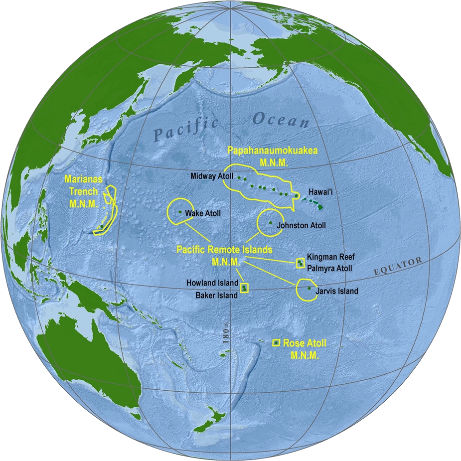
Figure 1. Image of Marine National Monuments in the Pacific Ocean via the U.S. Fish & Wildlife Service
PRIMNM’s reopening restores commercial fishing over the widest tract of the Pacific Ocean as it is a conglomeration of seven islands and atolls. While two of its islands, Wake and Johnston, are under Department of War control, it only extends to land and a 12 nautical mile water radius. With PRIMNM’s reopening, however, US commercial fishing spans out to 200 nautical miles. By covering up over half the US Pacific exclusive economic zones (EEZ), US-flagged vessels are pushed to the edges of international waters to compete with China’s distant water fleet. This restored fishing activity will not only draw commercial pressure but also give clearer rationale for the US Coast Guard and Navy patrol operations to be conducted.
Papahānaumokuākea stretches over 1,200 miles northwest from the Hawaiian Islands, a critical US military surveillance area for Pacific Ocean activity, and lies near the high-seas North Pacific. The high seas are governed by the North Pacific Fisheries Commission (NPFC), which excludes the EEZs of individual countries. While China can conduct a coast guard patrol in these regions, as they did in 2020, many consider these patrols gray zone tactics to assert maritime dominance. The high seas are directly off the monument’s northern boundary, which creates a legal grey zone where Chinese coast guard presence can expand with little tension. It is also important to note the monument’s 200 nautical mile end boundary is the start of NPFC high sea waters. By restoring a US commercial fishing presence there, it generates a greater US civilian maritime activity, bringing US commercial activity extremely close to Chinese vessels.
The Mariana Trench Monument’s Islands Unit covers 95,000 square miles along the EEZ boundary between the Northern Mariana Islands (NMI) and Guam. Guam is a central US force position as it sits roughly a quarter of the way from the Philippines to Hawaii. By opening the Islands unit to fishing, Guam’s surrounding waters have an increased level of routine civilian maritime traffic. This is noteworthy because Guam has interdependent maritime supply chains and shared military resources with NMI. A new civilian ship activity within the surrounding EEZ could complicate the surveillance systems that foreign vessels rely on for US military assets in the region. In effect, this would further embed civilian fishing traffic as part of extension of US military posture in the region.
Rose Atoll, near American Samoa, represents a different frontier of over 13,000 square miles. This monument sits at the edge of the South Pacific, where Chinese fishing expansion has gone unchecked, operating on the edge of Pacific Island EEZs with little to no enforcement capacity of their own. Notably, Rose Atoll is near three Pacific Island states, Fiji, Solomon Islands, and Vanuatu, where China has signed significant investment or trade framework agreements. Until now, the US has had little active commercial presence in these waters. Reopening this monument gives the region a US jurisdictional interest in a zone extremely close to where Chinese vessels have operated with increasing confidence.
All three monuments together form a rough arc across the Northern, Western, and Southern Pacific corridors, and areas along which China has been attempting to expand its maritime footprint.
President Trump’s June 11 proclamation is covered primarily as a deregulation story. But it’s also a strategic one. It places US fishing boats in the waters China has been quietly occupying nearby, in the northern, western, and southern Pacific. What happens next depends on whether Washington is prepared to back the move with new partnerships with Pacific Island communities, thereby making it more enforceable and effective.
Daniel Han Tae Choi is a research intern at Pacific Forum, a junior at Pomona College, and an Army ROTC cadet. His research focuses on US-ROK alliance dynamics and Indo-Pacific maritime security.
 - Both are government bodies under the Philippine government., modified, https://commons.wikimedia.org/wiki/File:Chinese_vessels_at_Whitsun_Reef.webp")


 The aircraft carrier USS George H.W. Bush (CVN 77) transits the Mediterranean Sea while performing flight operations in support of Operation Inherent Resolve. The George H.W. Bush Carrier Strike Group is conducting naval operations in the U.S. 6th Fleet area of operations in support of U.S. national security interests. (U.S. Navy photo by Mass Communication Specialist 3rd Class Daniel Gaither/Released)170221-N-OX430-129 Join the conversation: http://www.navy.mil/viewGallery.asp http://www.facebook.com/USNavy http://www.twitter.com/USNavy http://navylive.dodlive.mil http://pinterest.com https://plus.google.com, cc US Navy Page, modified, https://flickr.com/photos/usnavy/33052432475/in/photolist-SmJmDr-2jtyT73-2ndatj4-2iMQoqP-CcYk6h-2hNNrV3-2jgHW9E-2iZYXyx-dAPiWy-2jqnEFe-TTAtuT-AZj9cM-XGSSS7-2kcuWzW-2m6JLrj-2m8cBD1-u3AV5j-2enf1Fc-2nLogBn-SDACD1-2nTyqpE-2nTtuYw-nan8mD-2kcRndY-2nTyrjR-b3M4zv-2kVViic-2mkgQst-2kxJbjt-2mdr3S5-2iKAW3V-X7bU1N-nc2icJ-299CAXu-2mP2pPy-2kAx9Bp-2jc97bE-Lcazbb-2j7Ly9D-2jMrzYr-XWxVVK-2ihgtfm-2nWe3Un-2a1zEwu-2jBYK4B-2kM4Jze-2josuru-2gYijrT-2n3hu1B-2jGLRwn")


